Cowritten by co-written by Molly Schar, NSGIC Executive Director, and Nadine Alahmeh, OGC CEO –
It’s no secret, geospatial is mainstream, and it is everywhere. As leaders in the geospatial community, we’ve known this for a while, but it is refreshing to see experts across the globe agree.
There is a new wave of excitement in the location community since the Geospatial Data Act (GDA) of 2018 became law in 2018 in the United States. Beyond codifying the committees, processes, and tools used to develop, drive and manage the US National Spatial Data Infrastructure (NSDI), the GDA effectively represents a formal recognition of the essential role of geospatial data and technology in understanding and managing our world. For those not familiar, the US Federal Geographic Data Committee (FGDC) fact sheet serves as an excellent summary.
As always, the enactment of a law is only the beginning of a long journey. The GDA is no different. In order to reap the benefits of greater access and use of government data and information, there must be a minimal set of requirements with which agencies across the US will need to comply. In October 2020, multiple federal agencies shared the first GDA audit reports to the Inspectors General with the National Geospatial Advisory Committee (NGAC).
As a shared interest on behalf of their memberships, OGC and NSGIC took a closer look at a clause in the GDA that is related to standards compliance. We noticed a lack of clarity on the standards that need to be followed, had difficulty of determining what should be complied with, and noticed a lack of partnership with state and local stakeholders and their counterparts in the private sector on collection, integration, maintenance and preservation of geospatial data – amongst other issues (refer to the FGDC update as well as the NGDA Baseline Standards Inventory for more information).
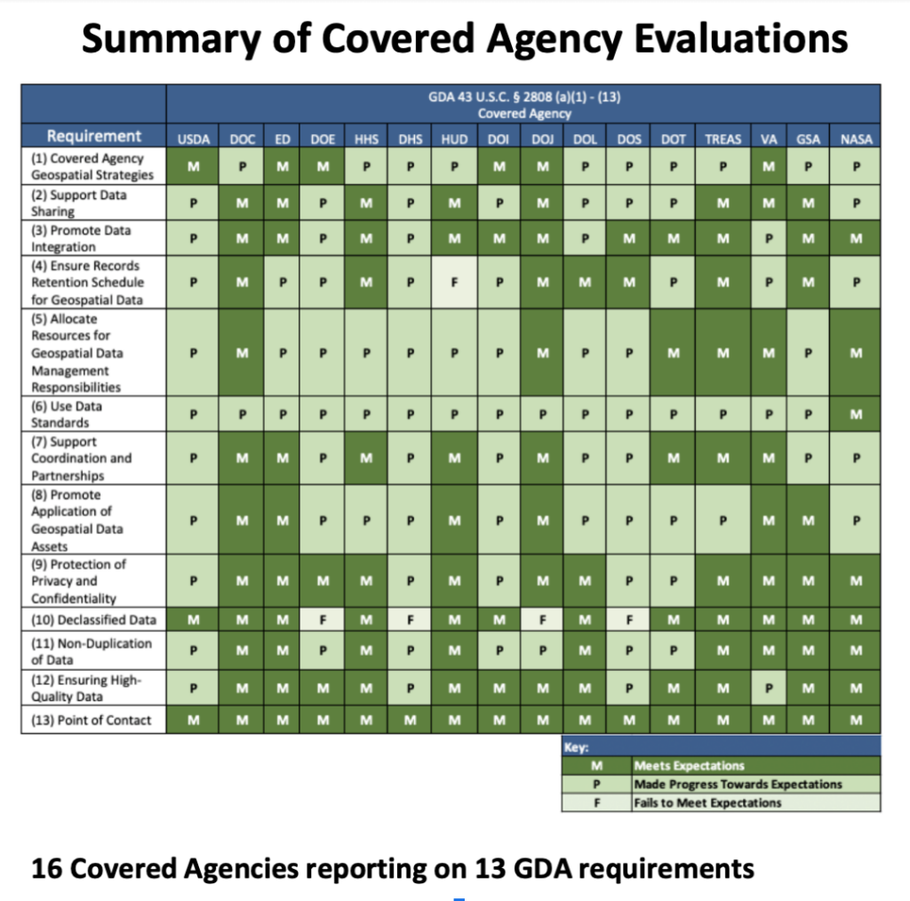
In April 2021, Federal GDA Lead and Covered Agencies provided the FGDC with their initial annual NGDA Theme assessment reports as required by the GDA. These reports, as well as a NGAC assessment of the GDA reporting process and approach, are available on the FGDC website. While a quick look at the online dashboard summarizing the state of compliance and the themes by agency indicates progress, the data raises a number of questions as to the degree of compliance of each agency/theme. We believe this uncertainty should prompt a discussion about the level of investment needed to fully meet the compliance criteria, but more importantly to reap the benefits of the GDA.


Based on the research put in by OGC and the NSGIC, the GDA implementation feels like it is in its early stages, with much work to be done on the data acquisition, standards, and collaboration/partnership fronts – areas that the joint geospatial community can champion, support and help clarify.
This has already led to an ongoing collaboration to host a series of community workshops, the first of which happened on June 24. The objective is to start a collaborative dialog on how the community can support and capitalize on the GDA; to advance the leveraging of geospatial data and technologies, in the federal government and to do that at the pace of innovation in today’s location world. Together we can identify opportunities to accelerate making geospatial information FAIR (Findable Accessible Interoperable and Reusable) by (1) identifying and advancing the development and adoption of the appropriate standards to be adopted, (2) forming and nurturing the right public private partnerships to best serve the US citizens and decision makers, and (3) hosting open community dialogs to address opportunities rising from common compliance and interoperability challenges.
Join us, OGC, NSGIC and the rest of the Geospatial community as we kick off a community dialog to make the most out of the GDA, to make the most out of Geospatial in the US.
If you want to go fast, go alone; if you want to go far, go together.
