
The Netherlands’ Cadastre, Land Registry, and Mapping Agency (Kadaster) maintains the nation’s register of land and property rights, ships, aircraft, and telecom networks. It’s also responsible for national mapping and the maintenance of the nation’s reference coordinate system and serves as an advisory body on land-use issues and national spatial data infrastructures. In its public service role, Kadaster handles millions of transactions a day.
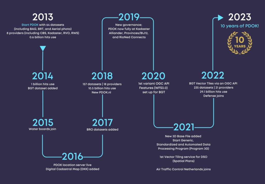
PDOK was launched in 2013 to make the Dutch government’s geospatial datasets Findable, Accessible, Interoperable, and Reusable (FAIR) as mandated by the EU’s INSPIRE Directive. OGC Standards have been foundational in ensuring that the country’s Spatial Data Infrastructure (SDI) is scalable, available, and responsive.
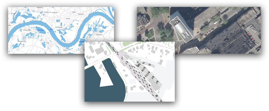
PDOK serves base maps and Earth Observation data for the whole country. It includes the Key Topography Register (Basisregistratie Topografie, BRT), aerial imagery (updated annually at 8 and 25 cm GSD), and the Large Scale Topography Register (Basisregistratie Grootschalige Topografie, BGT). The BGT is a detailed digital base map (between 1:500 and 1:5,000) that depicts building footprints, roads, water bodies, railways lines, agricultural land, and parcel boundaries. PDOK also serves a 3D dataset of buildings and terrain created from topography (BGT), building footprints (from the Building and Addresses Register or BAG), and height information (from aerial photography).
When PDOK was launched in 2013, it hosted 40 datasets and handled 580 million server requests annually. Today it hosts 210 datasets and handles 30 billion server requests annually—representing a 5,000% increase in service requests being handled by the platform.
Standards Enabling Success
The majority of datasets on PDOK are made available using OGC’s popular Web Map Service (WMS) and Web Feature Service (WFS) standards. The BRT is available in three coordinate reference systems (EPSG 28992, EPSG 25831, and EPSG 3857) using the Web Map Tile Service (WMTS) standard.
Kadaster is in the process of transitioning to the newer OGC API Standards, including OGC API – Tiles and OGC API – Features. The most frequently used key registers, like the Building and Addresses Register (BAG), the Large Scale Topography Register (BGT), and the Key Topography Register (BRT) are in the process of being migrated to these newer OGC APIs. The focus is on using OGC API – Tiles, specifically Vector Tiles. For query services the OGC API – Features Standard is used. Although Earth Observation data doesn’t currently use the newer APIs, aerial imagery is available through WM(T)S services, stored as OGC Cloud Optimized GeoTiffs (CoG). 3D Building data is encoded as OGC 3D Tiles and served using the OGC API – 3D GeoVolumes standard.
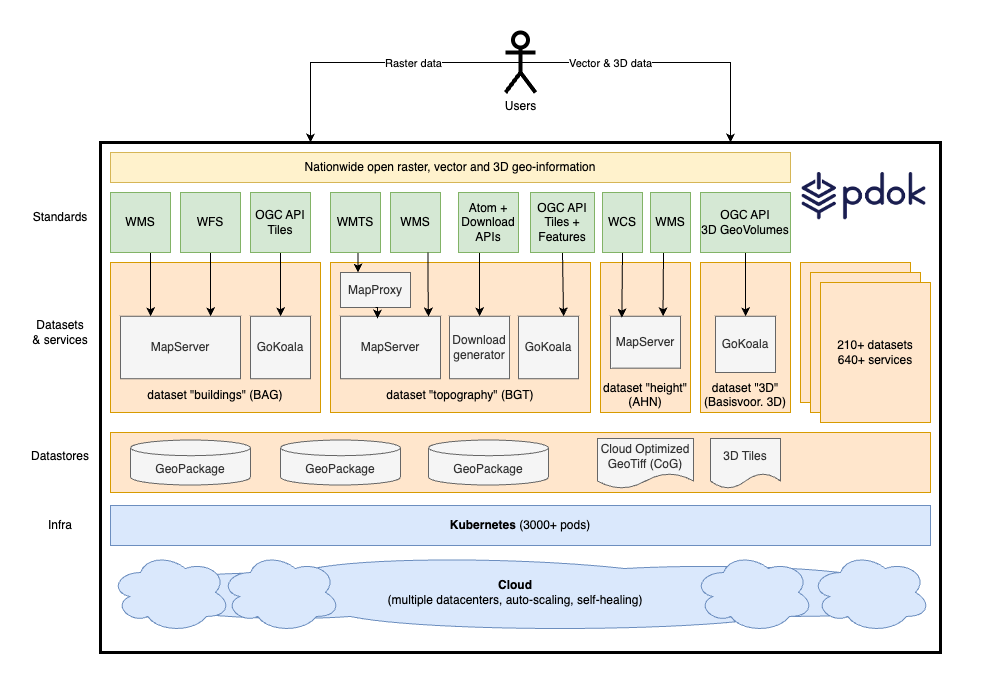
By using the newer OGC API Standards, Kadaster has found it significantly easier to handle the large volume of data in its national-scale 3D building dataset (which can be used between scales of 1:500 and 1:10,000) providing an unparalleled, high-resolution perspective of the country’s built environment.
OGC APIs also make it easier to track compute and memory usage on servers, allowing Kadaster to better realize platform scalability and optimize performance.

A Smooth Transition to OGC APIs
PDOK processes billions of user requests every month. Transitioning from OGC Web Services Standards to OGC APIs has meant Kadaster is able to efficiently handle the volume of requests it handles today – and can expect to handle in the future.
It took Kadaster little over a month to build their implementation of OGC API – Tiles. Following a short learning curve they were able to build out implementations of OGC API – Features and API – 3D GeoVolumes even faster. By making the move to deliver its geospatial tiles and feature data through an API conformant to the OGC API Standards, Kadaster continues to make government data Findable and Accessible.
PDOK implements what Kadaster calls the 3G principle—Generic (Generic), Geautomatiseerd (Automated) en Gestandaardiseerd (Standardized). This has led to simplified data processing, the automation of many manual processes, a standardization in services, and high standards in service design and operation – while at the same time remaining infrastructure independent. It has streamlined the adoption of new OGC Standards and made it better able to respond to changing user requirements.
Kadaster and OGC
Being an OGC Member allows Kadaster to leverage the collective knowledge of a global network of geospatial experts, while providing Kadaster with opportunities to contribute back to a community driven to use the power of geography and technology to solve problems faced by people and the planet.
Kadaster has recently contributed to the OGC Community by participating in an OGC Code Sprint. These hybrid online/in-person events give participants the opportunity to work on implementations of new or emerging OGC Standards.
Through OGC, Kadaster has also shared their experiences and challenges at OGC Member Meetings, contributing to the ongoing evolution of OGC Standards, Collaborative Solutions and Innovation (COSI) Program Initiatives, and, more broadly, advanced the “state of the art” of geospatial technologies.
The below video provides an overview of PDOK.