Post contributed by: Dr.-Ing. Jürgen Moßgraber
Deputy Head of Department “Information Management and Production Control”
Deputy Speaker of Business Unit “Energy, Environmental and Security Systems”
Fraunhofer Institute of Optronics, System Technologies and Image Exploitation IOSB
The European Commission has a long history of promoting open access to public data across Europe, breaking down electronic barriers at national borders through the creation of common data and service models, as well as through the provision of accompanying legislation to facilitate such endeavours. The INSPIRE Directive, entered into force in May 2007, has been a core building block in this work.
INSPIRE established an infrastructure for spatial information in Europe in support of Community environmental policies and policies or activities that may impact the environment. INSPIRE is based on the infrastructures for spatial information established and operated by the Member States of the European Union. The Directive addresses 34 spatial data themes needed for environmental applications, with key components specified through technical implementing rules.
The API4INSPIRE Project
The API4INSPIRE Project investigated new developments in geospatial standards and technologies, foremost the new OGC API – Features and OGC SensorThings API Standards (which are now both INSPIRE Good Practice), together with the outcomes of the INSPIRE MIG Action 2017.2 on alternative encodings for INSPIRE data, evaluating their suitability for use in the European spatial data landscape. This study was funded in the frame of the European Location Interoperability Solutions for e-Government action (ELISE), part of the ISA Programme and was conducted by researchers from Fraunhofer IOSB, GeoSolutions and DataCove, all of whom have extensive experience with OGC standards and services.
The Methodology
First, an evaluation strategy was developed to determine how these new and emerging standards can best be utilized to leverage existing investments by EU Member States in the INSPIRE implementation, while also supporting new developments in e-Government and the Digital Single Market. The evaluation methodology was designed to weigh costs and benefits against each other, highlighting both strengths and weaknesses of the APIs being evaluated. Pertaining to benefits, this includes flexibility, developer friendliness, and ease of discoverability, access and use. From a technical point of view, alignment with the current architecture of the Web and the Spatial Data on the Web Best Practices should be assured. Cost considerations, such as infrastructural changes, need for additional expertise, updated tooling, training, re-engineering of existing practices and security aspects were included as well. While quantifiable metrics would have been preferable, the effort entailed in gaining truly representative values would require a level of complexity that outweighs the assumed benefits of such quantification; thus it was decided to focus on qualitative metrics that can be easily abstracted to different operational environments.
The Data Providers
Six data providers from Germany, France, and Austria contributed data, personnel, and infrastructure to this project and were involved in all phases of the project. Together, these data providers manage data from 14 INSPIRE topics (including air and water quality, and traffic data). Use cases were defined based on the available datasets and the data providers’ experiences with their current data consumers. Priority was given to use cases that included APIs where possible from different vendors. Numerous data sets were made available online as part of the project and further steps were taken to evaluate the usability of the data via these new APIs. This provides insights into both the usability of each API standard and the interoperability between API standards.
The Results
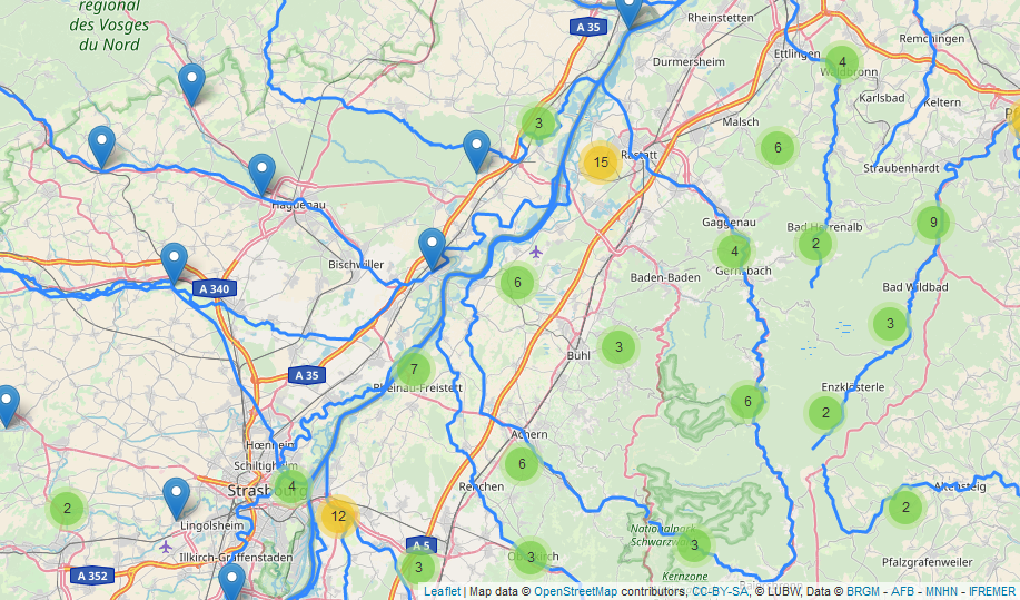
The evaluation focused on various facets of usability ranging from the configuration and deployment aspects of service deployment to ease of uptake of the API, and included a wide range of stakeholders within the evaluation process. The outcomes of this investigation were analysed, relevant guidance materials created based on insights gained, and widely disseminated to interested stakeholders. In addition, various Open Source software solutions as well as extensions were developed where gaps were identified (e.g. for GeoServer). For the provision of SensorThings API the Fraunhofer Open Source SensorThings Server (FROST) is already available as a free solution and allows for a much faster implementation of real-world applications. In one of the use-cases data from both the German and French sides of the river Rhine, integrating data from the German State of Baden-Württemberg (LUBW) with that stemming from the French Geological Survey (BRGM) and the French Office for Biodiversity (OFB) provided alternative perspectives on the Rhine (see image).

A central result of the project is the recommendation of both OGC API – Features and OGC SensorThings API Standards as “good practice” for the provision of INSPIRE data. The documentation of the evaluation method and deployment strategies developed for standards-based APIs, as well as the practical experiences of deploying and using the APIs in the context of the defined use cases, can be accessed on the API4INSPIRE project page.
