After three years of collaborative development, the release of the first iteration of the IGIF-(M)SDI Maturity Roadmap is a milestone moment in exploiting geospatial data for the inclusive socio-economic development of nations. This Maturity Roadmap – involving the UK Hydrographic Office (UKHO) as lead sponsor, as well as the Open Geospatial Consortium (OGC), the World Bank Group, and the US National Oceanic and Atmospheric Administration (NOAA) – complements existing resources by providing a quantitative toolkit for nations, ministries, departments, agencies, regions, municipalities, and even individual cities or ports, to benchmark their geospatial development against the United Nations’ Integrated Geospatial Information Framework (IGIF) principles. This independent initiative aligns with, and supports, the mission, vision, and goals of the UN-GGIM initiative (Global Geospatial Information Management), who developed the IGIF core principles for all geospatial data considerations.
(Marine) Spatial Data Infrastructure
IGIF provides a vision for developing and strengthening geospatial information management, to assist countries in bridging the geospatial digital divide, secure socio-economic prosperity, and leave no community behind. Marine Spatial Data Infrastructure ((M)SDI) is the International Hydrographic Organization (IHO)’s concept for a future ecosystem of marine data services that can enable the IGIF vision to become a reality. Empowered by OGC standards, the interoperable (M)SDI data services can “make it real through technology.” Bringing these elements together in a straightforward and accessible document, the intent of the Maturity Roadmap is to provide a quantitative “quick start” or “stepping stone” for nations beginning an IGIF-aligned (M)SDI implementation.
With its terrestrial heritage, the World Bank SDI Diagnostic Toolkit is augmented with IHO and OGC contributions to maximise its benefits to the marine community, while remaining aligned with the IGIF principles and, therefore, the UN Sustainable Development Goals (SDGs). As a guiding simplification, the involvement of the World Bank is crucial in providing answers for questions around financing (including business cases), alongside the ‘why’ (UN), ‘what’ (IHO), and ‘how’ (OGC). This aspect of measuring socio-economic return is commonly a key hurdle that prevents real-world progress beyond concepts and ideas. The modular IHO and OGC additions ensure interoperability with the World Bank IGIF methodology, which can lead to the financing of approved (M)SDI development projects. Even as an independent tool, undertaking an (M)SDI assessment provides a clear reference point aligned with international best practice. Without such a starting point, progress towards any (M)SDI end-state will be difficult to govern and manage.
Fully interoperable across all geospatial domains
As part of the OGC’s Federated Marine SDI (FMSDI) initiative, the Maturity Roadmap seeks to promote the inclusive development of an IGIF-Aligned (M)SDI as the marine and maritime community’s contribution to an all-domain National Spatial Data Infrastructure (NSDI) across air, land, sea, space, and cyberspace. Although initially adapted for marine considerations, the Maturity Roadmap is fully interoperable across all geospatial domains and scalable from the national level to regions, municipalities, cities, ports, and government departments or agencies.

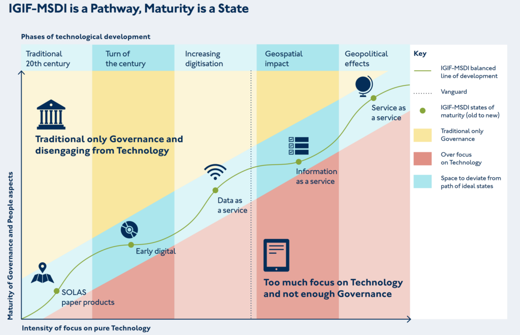
Within the Maturity Roadmap, the concept of an IGIF-(M)SDI Balanced Pathway of Development seeks to promote inclusive geospatial development via two key messages: ‘driving technology, not being driven by technology’ and ‘making the data count, not just counting the data.’
These twin ideas promote the effective governance of technology & standards to meet sovereign national requirements, however expansive or constrained, over the acquisition and possession of the latest technological solutions independent of cost-benefit considerations. OGC contributes to this by providing best practice around the implementation of standards, alongside an active cross-sector global forum to share applied knowledge, cooperate on emerging technologies, and collaborate on standards development. The engagement of the OGC membership at all levels of socio-economic development is vital for realising the cost benefits stemming from the common implementation of technologies across different countries, regions, sectors, and communities, regardless of economic spend.
The benefits of benchmarking IGIF-MSDI maturity
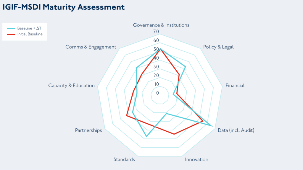
When objectively and independently applied, the benchmarking provided by the IGIF-(M)SDI Maturity Roadmap offers a useful planning and comparison baseline for countries undertaking a public geospatial development programme. The example here is a radar chart output across nine assessment categories corresponding to the IGIF Nine Pathways, for an initial baseline – and a subsequent baseline two years later. The underlying data is from real-world assessments taken under World Bank and partner oversight, which was openly published by the Agency for Land Relations and Cadastre of the Republic of Moldova. Such benchmarking exercises can be executed across different scales (from whole nations to cities or ports) and across different domains (from space to cyberspace), sometimes yielding deep insights into potential opportunities around discovered disparities.

Also included with the Maturity Roadmap is a practically orientated appendix that covers best practice for multi-agency governance, where, during a national geospatial development programme, multiple agencies or departments may have to work closely to operationally deliver joint geospatial outcomes. This may be useful in situations where long-standing traditions and conventions could have created a culture that is not conducive to the tight-knit cooperation needed to develop complex IGIF-(M)SDI solutions. Such solutions require the pooling of expertise, resources, and capabilities that one or even two agencies can not provide alone.
Positive approach to improve ineffective practices is essential to joint IGIF-(M)SDI success
One crucial characteristic for joint IGIF-(M)SDI success is a healthy scepticism and a drive to improve ineffective practices, especially when they have become entrenched as tradition, convention, or “how things have always been done.” I like to counter such perceptions, particularly amongst those that genuinely want to evolve, with the view that “if you always do what you’ve always done, you’ll always get what you’ve always gotten.” Long-term existing practices may have been fine because they met some requirement in a particular environment and once satisfied a need effectively. However, maintaining those same practices now, when society’s expectations and technology have moved forward, can lead to stagnation.
Departments and agencies should foster a keen interest in human behaviour around the use (and misuse) of data or information. Traditional or conventional “hard governance” centres around the assumption that people only make the wrong decisions because they have the wrong information or not enough of it. This traditional view of data governance then coalesces into hard compliance measures and management surveillance, which includes formal audits, regular in-depth reporting, restrictive checklists, and a focus on top-down, non-negotiable command & control. This approach was suited to traditional mass manufacturing of standardised products, but is insufficient by itself for modern data services that are digital-first by design and characterised by near real-time changes.
Soft governance works with the grain of human behaviour to achieve better results by enablement and empowerment, rather than by command and control alone. Principles take precedent over prescription, thus allowing an organisation to leverage the deep insights and frontline experiences of their entire workforce. Shortcut thinking, lack of active engagement and wrong assumptions are some of the key targets for a soft governance approach, which still requires the ultimate backstop of hard governance – but meaningfully targeted and monitored using a risk-based approach. Combining the two approaches can yield outsized and transformative results, which is essential for joint IGIF-(M)SDI success that leaves no community behind.
The IGIF-(M)SDI Maturity Roadmap and related resources are available for free on OGC’s IGIF-(M)SDI Maturity Roadmap webpage.
To best inform future revisions, iterations, and the optimization of the Roadmap, feedback and applied experiences from the geospatial community are sought via OGC Member Meetings, Forums, or directly.
The IGIF-(M)SDI Maturity Roadmap is an independent initiative not endorsed by or officially connected to, but in alignment and support of, the mission, vision, and goals of the United Nations Initiative on Global Geospatial Information Management (UN-GGIM).

Dr. Gerald J Wong is the Data Governance Lead at the United Kingdom Hydrographic Office (UKHO), which is a world-leading centre for hydrography and an executive agency of the Ministry of Defence (MoD). Dr Wong is the Lead Author of the IGIF-(M)SDI Maturity Roadmap, being a specialist in synergising traditional rules-based hard governance with modern and empowering soft governance, which works with the grain of human behaviour to achieve better outcomes.
As an OGC Strategic Member and a sponsor of OGC’s FMSDI initiative, the United Kingdom Hydrographic Office (UKHO) is the UK’s agency for providing hydrographic and marine geospatial data to mariners and maritime organisations across the world. The UKHO is responsible for operational support to the Royal Navy and other defence customers. Supplying defence and the commercial shipping industry, the organisation helps ensure Safety of Life at Sea (SOLAS), protect the marine environment, and support the efficiency of global trade.
Together with other national hydrographic offices and the International Hydrographic Organization (IHO), the UKHO works to develop and raise global standards of hydrography, cartography, and navigation. The UKHO also produces a commercial portfolio of ADMIRALTY Maritime Data Solutions, providing SOLAS-compliant charts, publications, and digital services for ships trading internationally.
